Stretton Skyline Fell Race - September 18th 2005
There are numerous great pics of the Church Stretton area on the web - click the photo below to view a few of them.
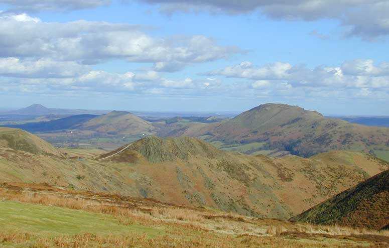
This was my longest fell race to date, just eclipsing the Black Mountains. The Stretton Skyline is 18 miles and around 4500' of ascent. None of these beautiful, ancient hills is much above 1500', but the ascents are steep in places and there are 5 major climbs - enough to provide a serious challenge to compliment the enjoyment of such a scenic course. You need both in a great fell race really - the uplifting views and the oxygen debt :)
From the registration (a small social club with a village-hall type vibe) we walked a mile or so up the Cardingmill Valley to a large car park. There are numerous roads over the Longmynd as well as trails and twisty paths and this particular valley is a mecca for coach parties who get to view the hills from the comfort of a reclining seat. People had come from all over the place for this race - there were lots of Mercia and Telford runners (the lattter host the event - thanks!!) and some London clubs (Ranelagh, Thames Hare & Hounds) as well as Shepshed, Newport etc. etc. From Wales we had the MDC of course and moi of Sri Chinmoy AC in Cardiff.
From the start, the route took us up the valley on wide stoney paths which narrowed as we came to the valley head - the initial stretch is mandatory but up top you get some route choice - as a novice I chose wrong (as did many others) and missed a shortcut through the bracken, so I sped up to catch the runners who had been just behind me and found myself breathless at the first checkpoint (Pole Bank). Still, that whole first climb was runnable for me. Not so with the remaining four!
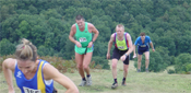
Click on this pic for the original version at Telford Running. Thats me at the back looking disappointingly ungainly :(
From Pole Bank there are several ways down to Little Stretton but I followed the crowd down the flank of a spur (obvious path on the map). At the road crossing in Little Stretton there were cups of water - the race is arranged so you can grab a cupful after each hill, but most were carrying a bit extra in bottles, camelbaks or waistpacks. I'd opted for 3 300ml bottles in the bum bag - of electrolyte drink - but the first one tasted strong and was giving me a bit of stomach cramp so I poured them out and refilled with water at the various drink stations. This stopped me for a minute or two in total but it was worth it - 18 miles is too far, without good hydration, for all but the most masochistic spartan. There were short road sections but mostly easy trails as we headed for climb number two - Ragleth. This is a really steep hill that you see on the southern approach to Church Stretton - I believe it has it's own short fell race? Anyhow, I walked most of this and was able to step up to a reasonable pace up top. The map shows an obvious descent straight north from the summit but gossip in the race HQ earlier had forewarned me that the sharp left off the ridge was better, avoiding some nightmare bracken. The runners ahead of me obviously knew this and we all took a lefty at the rocky pinnacle along the ridge from the checkpoint and found an easy route through airy woodland onto a path. We came out in Church Stretton - more water available here - and began to wend our way to the base of Caer Caradoc.

The photo (taken before the race) is a bit lame but Caradoc is a craggy-topped and steep-sided grassy dome of a hill with ancient remains at the top - named after a celtic king I believe (Caradoc aka Caractacus). This was another walking ascent for me - I wasn't losing my position and I was keeping some energy in reserve so felt no need to jog these steep stair-like climbs.
After Caradoc theres another drink opportunity then a slog up the steep end of a proud, narrow ridge called The Lawley. FAlse horizons appear to be the top, but each one passes to reveal a bit more climbing. Here the return from the summit is the same as the way up, so the drink station is visited twice. You get to see the leaders coming down as you reach the bottom of the hill, and conversely to see those who are several minutes behind you as you come down. Handy for the competitive types :)
After overtaking a couple of runners on the descent from the Lawley I started the signposted section across fields & styles to the base of the Longmynd. I was really dying all of a sudden - feet giving me a lot of pain and energy-wise I was pretty close to "blowing up" as they say. Loosening my laces helped the feet and I kept shuffling on. When the climb started - a long slog on a narrow lane - I was reduced to walking and so were most of those around me. This ascent, known as the Gogbatch, goes on and on. I took the higher path at the fork but the lower one is probably no longer - you just choose between a steep slope earlier or later - I opted to get it over and done with then have a flat approach to the checkpoint. Just as I got there the runners I'd overtaken on the Lawley came back past me, along with a couple of others. They must have given a lot on the climb though, as I found myself cruising more quickly down the stoney path of the final descent (again through the Cardingmill Valley) and regaining my place ahead of them. Usually I'm slower on the way down than the more experienced fell runners, but I've apparently acquired some more leg strength from the long hauls I've done this summer and this is making the downhills quicker and easier.
Nice course, great climbs, very taxing final ascent, superb organisation by Telford AC. Takes me three hours to get into the heart of Shropshire but well worth it.